


I have read a few posts, talked to a few people (and seen one or two myself!) about the hazards in Franks Tract and Little Franks. Things like sunken duck blinds, pilings, a piece of rebar and other snags and such.
I'm sure I'm not the only one who not only doesn't know where they are, but also doesn't want to find them "the hard way"!
Would any of you be willing to share the GPS coordinates of any of the hidden hazards or dangerous spots out there? For that matter, how 'bout any of the other areas in the delta: Big Break, Mildred, any of the sloughs, etc. Help a fellow angler from ruining his day!
Thanks A Bunch!
Help Us Mark The Delta Hazards! GPS Coordinates Anyone?
Help Us Mark The Delta Hazards! GPS Coordinates Anyone?
Last edited by Ken C. on Mon Jun 05, 2006 9:24 am, edited 2 times in total.
[i][b]To the world, you might be just one person. But to one person, you just might be the world...[/b][/i]
[img]http://i13.photobucket.com/albums/a266/shred1080/misc/Disclaimer.jpg[/img] [img]http://www.danasoft.com/sig/Kadota.jpg[/img]
[img]http://i13.photobucket.com/albums/a266/shred1080/misc/Disclaimer.jpg[/img] [img]http://www.danasoft.com/sig/Kadota.jpg[/img]
-
Jeff Jewell
- Posts: 533
- Joined: Sat May 07, 2005 5:18 pm
- Location: Suisun City
Re: Franks Tract/Little Franks - Hazard GPS Coordinates Anyo
excellent idea Ken!! I'm with you I don't want to find out the hard way either.............
..................................................................
When in Doubt " Set the Hook"
When in Doubt " Set the Hook"

Re: Franks Tract/Little Franks - Hazard GPS Coordinates Anyo
If we could get this going, I am sure I could fire up a map or list with locations and GPS coordinates and keep it here on the site. I do not have ANY of this information so I know I would definitely appreciate the safety info.
Re: Franks Tract/Little Franks - Hazard GPS Coordinates Anyo
It's possible to show a google map with the coordinates, have done projects like these in the past. (http://www.revenuetoday.com/bnstores/bnstores.asp) fairly easy and free and easy to link to from this site per Gator point/idea above, should have enough detail to give people a general idea of where it is and also display the actual coordinates so that they can punch them into their GPS unit
Actually started doing a similar system to the above for delta weather/tide that showed on a google map but got busy with other things and never finished it
Happy to help out if help is needed.
Actually started doing a similar system to the above for delta weather/tide that showed on a google map but got busy with other things and never finished it
Happy to help out if help is needed.

Re: Franks Tract/Little Franks - Hazard GPS Coordinates Anyo
Ken, I don’t have a GPS but one day, in the near future – the Lord willing!
I run the Delta all the time and when I first started I was scared I would run into something or other. But what I did do was study my Delta Map (Fish-n-Map CO.). This is the Map all of the Fishing stores sell. In the “Legendâ€
I run the Delta all the time and when I first started I was scared I would run into something or other. But what I did do was study my Delta Map (Fish-n-Map CO.). This is the Map all of the Fishing stores sell. In the “Legendâ€

-
Fishin' Dave

- Posts: 1797
- Joined: Mon May 09, 2005 8:09 am
- Location: Felix, Ca.
- Contact:
Re: Franks Tract/Little Franks - Hazard GPS Coordinates Anyo
Watch out for Cooch's lower unit!
Re: Franks Tract/Little Franks - Hazard GPS Coordinates Anyo
Much needed information and I hope the ball keeps rolling on this idea. Ken
Re: Franks Tract/Little Franks - Hazard GPS Coordinates Anyo
Man great post.
One thing im doing is saving my trails on my gps.
If i make it safe through a place i just follow the same trail each time.
The only thing is that arrow on the screen is big and you could be off by a few feet if not more im not sure.
One thing im doing is saving my trails on my gps.
If i make it safe through a place i just follow the same trail each time.
The only thing is that arrow on the screen is big and you could be off by a few feet if not more im not sure.
Re: Help Us Mark The Delta Hazards! GPS Coordinates Anyone?
I collect old/out of print books on the Delta and if you can track down a 1976 edition of Cruising The California Delta II (Haessner Publishing, Inc.) you'll find a map of Frank's Tract with "cruiser channels." They're not official navigation channels but are informal routes based on old, local knowledge. A couple of the channels follow the old routes where telephone poles were driven across the tract (Long Pole Line and Short Pole Line); the poles were chopped down decades ago but the the old sight lines were apparently used as travelling routes.
If you compare these old cruiser channels in the book to the depths printed in the more current Fish-n-Map Co. map, you can see how they coincide with the deeper sections of the Tract (6,7,8 foot depths) .
Note: Cruising The California Delta II is actually a revised version of Cruising The California Delta (1972, Miller Freeman Publications, Inc.) by Robert E. Walters. The map is in both editions.
-
Guest
Re: Help Us Mark The Delta Hazards! GPS Coordinates Anyone?
Thanks for the info on the book. There are 5 available on amazon.com in the used section and I just placed an order for one of them.
What other books on the CA Delta do you have in your library?
What other books on the CA Delta do you have in your library?
-
Guest
Re: Help Us Mark The Delta Hazards! GPS Coordinates Anyone?
So the big issue with marking these hazards is coordinating data from multiple sources and exporting the data to multiple file formats based on your GPS manufacturer.
Question:
Which GPS mfr does everyone use or would like the file format?
I specifically use a Garmin GPSMAP 168 and the Garmin Mapsource software. The other major mfr I see on the market is Lowrance which uses more of a chip based technology to load data.
What other applications or products does everyone else use for their GPS?
Re: Help Us Mark The Delta Hazards! GPS Coordinates Anyone?
> What other books on the CA Delta do you have in your library?
Vince,
I'm not a serious collector but if I see an old book on the Delta or the surrounding region (San Joaquin Valley) I'll buy it. I usually find 'em in the California history section of used bookstores but ebay can be a good source too.
I've got some photo books on the land/people of the Delta, some that focus on the Chinese settlement of the region and some cruising books from the 60s and 70s. Erle Stanley Gardner (he wrote the old Perry Mason books and teevee show) has a few books on cruising the Delta--he kept his houseboats at Tiki Lagun. Anyway, I mainly like buying these books for the pictures of the Delta in the old days and to compare it to what we know it as today.
Re: Help Us Mark The Delta Hazards! GPS Coordinates Anyone?
Vince,
What I was hoping to get compiled is a simple list of co-ordinates that we could just enter into our own respective units to mark hazards.
Simple to do. If anyone has a hazard marked (typically as a waypoint) on their GPS they can move the cursor over the waypoint and the unit should display the coordinates.
Next just post those coordinates and the name of the general area or type of hazard (i.e., sunken barge) on the forum. Then hopefully Gator or someone can create a sticky that compiles all of these markers!
Now if someone wants to get really busy and enter those onto a Google Earth type of map then that would be awesome as well, but my main idea (yes, every once in awhile even I get one of those ) was just a simple list to make the delta a safer place for us all!
What I was hoping to get compiled is a simple list of co-ordinates that we could just enter into our own respective units to mark hazards.
Simple to do. If anyone has a hazard marked (typically as a waypoint) on their GPS they can move the cursor over the waypoint and the unit should display the coordinates.
Next just post those coordinates and the name of the general area or type of hazard (i.e., sunken barge) on the forum. Then hopefully Gator or someone can create a sticky that compiles all of these markers!
Now if someone wants to get really busy and enter those onto a Google Earth type of map then that would be awesome as well, but my main idea (yes, every once in awhile even I get one of those
[i][b]To the world, you might be just one person. But to one person, you just might be the world...[/b][/i]
[img]http://i13.photobucket.com/albums/a266/shred1080/misc/Disclaimer.jpg[/img] [img]http://www.danasoft.com/sig/Kadota.jpg[/img]
[img]http://i13.photobucket.com/albums/a266/shred1080/misc/Disclaimer.jpg[/img] [img]http://www.danasoft.com/sig/Kadota.jpg[/img]
-
TomAtkeson

- Posts: 737
- Joined: Sat May 07, 2005 12:33 pm
- Location: Pittsburg CA
Re: Help Us Mark The Delta Hazards! GPS Coordinates Anyone?
You can also try contacting USCG Station Rio Vista they may have thier own list of known hazards in that area and may be able to pass those along to help this project out.
Tom Atkeson
http://www.blackdogbaitco.com
http://www.tylurecustombaits.com
http://www.skinnybearbassjigs.com
http://www.youtube.com/ibassfishing
http://www.blackdogbaitco.com
http://www.tylurecustombaits.com
http://www.skinnybearbassjigs.com
http://www.youtube.com/ibassfishing
Re: Help Us Mark The Delta Hazards! GPS Coordinates Anyone?
Good idea Tom! Have any contact info? Maybe somebody out ther has contacts for the Sheriff Marine office and maybe even Vessel Assist!
[i][b]To the world, you might be just one person. But to one person, you just might be the world...[/b][/i]
[img]http://i13.photobucket.com/albums/a266/shred1080/misc/Disclaimer.jpg[/img] [img]http://www.danasoft.com/sig/Kadota.jpg[/img]
[img]http://i13.photobucket.com/albums/a266/shred1080/misc/Disclaimer.jpg[/img] [img]http://www.danasoft.com/sig/Kadota.jpg[/img]
-
TomAtkeson
- Posts: 737
- Joined: Sat May 07, 2005 12:33 pm
- Location: Pittsburg CA
Some contact info that may help.
USCG STA RioVista (707) 374 6477
COCO County Sherrif Marine unit (925) 427 8507
Antioch VSL Assist (925) 757 2623
Hope this helps you.
COCO County Sherrif Marine unit (925) 427 8507
Antioch VSL Assist (925) 757 2623
Hope this helps you.
Tom Atkeson
http://www.blackdogbaitco.com
http://www.tylurecustombaits.com
http://www.skinnybearbassjigs.com
http://www.youtube.com/ibassfishing
http://www.blackdogbaitco.com
http://www.tylurecustombaits.com
http://www.skinnybearbassjigs.com
http://www.youtube.com/ibassfishing
-
Guest
Re: Help Us Mark The Delta Hazards! GPS Coordinates Anyone?
Ken,
Probably the best way to store all of these is to compile them into a GPX format so that it can be interchanged between multiple GPS programs. Here's some info on the GPX format:
http://www.topografix.com/gpx.asp
Aside from using my GPS with fishing and back country hiking/backpacking I also use my handheld for geocaching -- see http://www.geocaching.com. The problem that has always existed is that there are mutiple GPS platforms that use different Datums. Read the link below for an example of using different Datums:
http://www.nb.net/~resteele/newsites/gpsdatum.htm
An example was that recently I was updating my GPS map on my boat for the GPS marks with the Fish-n-map of Lake Don Pedro for a night tournament. That way when I'm traveling in the middle of the night I have a number of navigational reference points when running a specific pattern this weekend. To successfully use these coordinates you have to switch your Datum to NAD 83 as mentioned by the map. If not the coodinates will be significantly off and if not careful one could end up on land if they were going by the GPS alone.
Here's another good source for gps information in general:
http://en.wikipedia.org/wiki/Global_Positioning_System
GPS Accuracy
Then there is the question of GPS accuracy especially if these are used for marking navigational hazards. See the following links:
http://www.garmin.com/aboutGPS/
http://www.ja-gps.com.au/indexprodaccu.html
Maybe the best bet is to contact NOAA to see if there are any projects currently in process and see if we can assist in some way. This way we can ensure that the marked hazards will eventually make it's way into our maps and GPS products in the future. I'd be willing to help with this project in any way that I can.
Last edited by Guest on Wed Jun 07, 2006 11:13 am, edited 1 time in total.
-
Guest
Re: Help Us Mark The Delta Hazards! GPS Coordinates Anyone?
FYI,
This might interest you. I was browsing around the NOAA website and found a few online databases of old maps for the delta.
http://historicals.ncd.noaa.gov/historicals/histmap.asp
http://nauticalcharts.noaa.gov/csdl/ctp/abstract.htm
Just perform a search for "San Joaquin River"
San Joaquin River CA NAUTICAL CHART 1969
San Joaquin River CA NAUTICAL CHART 1967
San Joaquin River CA NAUTICAL CHART 1966
San Joaquin River CA NAUTICAL CHART 1948
San Joaquin River CA NAUTICAL CHART 1968
-
TomAtkeson
- Posts: 737
- Joined: Sat May 07, 2005 12:33 pm
- Location: Pittsburg CA
Re: Some contact info that may help.
Im assuming you want to talk to some one with NOAAs NWS service I found two contacts for you
SanFrancisco bay area office
Dave Soroka
831-656-1725
David.Soroka@noaa.gov
Sacramento office
Kathy Hoxsie
916-979-3041
Kathryn.Hoxsie@noaa.gov
If this is not the areas you are interested in here is the map of california areas and contacts for each
http://www.stormready.noaa.gov/stormmaps/ca-cwa.htm
Tom Atkeson
http://www.blackdogbaitco.com
http://www.tylurecustombaits.com
http://www.skinnybearbassjigs.com
http://www.youtube.com/ibassfishing
http://www.blackdogbaitco.com
http://www.tylurecustombaits.com
http://www.skinnybearbassjigs.com
http://www.youtube.com/ibassfishing
-
TomAtkeson
- Posts: 737
- Joined: Sat May 07, 2005 12:33 pm
- Location: Pittsburg CA
Re: Some contact info that may help.
Ok so I read the rest of the posts below and you didnt want NWS I dont know what branch would controll some thing like this but maybe those other two contacts can send you in the right direction....Sorry!
Tom Atkeson
http://www.blackdogbaitco.com
http://www.tylurecustombaits.com
http://www.skinnybearbassjigs.com
http://www.youtube.com/ibassfishing
http://www.blackdogbaitco.com
http://www.tylurecustombaits.com
http://www.skinnybearbassjigs.com
http://www.youtube.com/ibassfishing
-
Jim Wilson

- Posts: 172
- Joined: Mon Jun 27, 2005 10:29 am
- Location: Brentwood, CA
Re: Help Us Mark The Delta Hazards! GPS Coordinates Anyone?
I was surfing and came up with this in a thread about hazards in Franks Tract. Check out the thread at www.boatered.com. Just enter Franks Tract in a forum search.
Here are the Latitudes and Longitudes of the duck blind wrecks on Franks Tract...AS THEY APPEAR IN MY GPS. These postions are approximate only. If you hit one it is not my fault. If you do hit one, you know who to call
First blind sunk in the 2003 hunting season
38 02.535
121 36.140
2004 Season
38 02.742
121 35.790
And Last years
38 03.025
121 35.381
The first two are almost never visible above the surface, but I believe they do pose a threat to props, shafts, ect. The most recent is very visible at all tides...currently.
Phil Delano
Vessel Assist/BoatU.S.
SF Bay & Delta
24 hour Salvage & Towing
Jim
-
upriverLMB

- Posts: 239
- Joined: Sat Jan 28, 2006 2:35 pm
- Location: Modesto
Re: Help Us Mark The Delta Hazards! GPS Coordinates Anyone?
Finally, actual coordinates. Thanks Jim
LMB
Re: Help Us Mark The Delta Hazards! GPS Coordinates Anyone?
That's what I'm talkin' about! Thanks for posting. I'll enter those into my various GPS units and go there to see what I come up with and report back...
[i][b]To the world, you might be just one person. But to one person, you just might be the world...[/b][/i]
[img]http://i13.photobucket.com/albums/a266/shred1080/misc/Disclaimer.jpg[/img] [img]http://www.danasoft.com/sig/Kadota.jpg[/img]
[img]http://i13.photobucket.com/albums/a266/shred1080/misc/Disclaimer.jpg[/img] [img]http://www.danasoft.com/sig/Kadota.jpg[/img]
-
upriverLMB
- Posts: 239
- Joined: Sat Jan 28, 2006 2:35 pm
- Location: Modesto
Re: Help Us Mark The Delta Hazards! GPS Coordinates Anyone?
Jim you are dead on
there is a telephone pole size post with orange paint on top
at N 38o02,702 W 121o37,523 in franks. My brother in law hit it last weekend. He said at 0.4 tide it is 6" under the water. He now has a scull and cross bone icon at that location
Thanks
there is a telephone pole size post with orange paint on top
at N 38o02,702 W 121o37,523 in franks. My brother in law hit it last weekend. He said at 0.4 tide it is 6" under the water. He now has a scull and cross bone icon at that location
Thanks
LMB
Recapping:
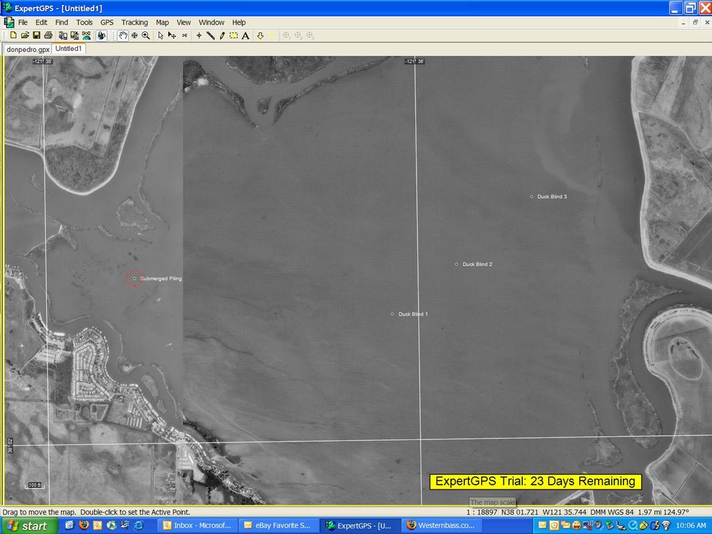
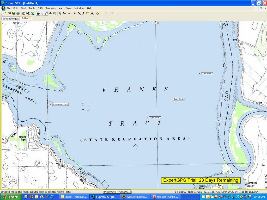
OK, so here's what hazards we have so far: (all in the format of Nxx xx.xxx / Wxx xx.xxx)
38 02.535 / 121 36.140 - Duck Blind
38 02.742 / 121 35.790 - Duck Blind
38 03.025 / 121 35.381 - Duck Blind
38 02.702 / 121 37.523 - Submerged Piling
Can anyone who has provided coordinates confirm their GPS is set to use the WGS84 Map Datum (Use your menu function to find GPS Set-up/Map Datum Selection to see your setting)
Thanks, and please keep them coming and keep this thread alive - your lower unit will love you for it!
[i][b]To the world, you might be just one person. But to one person, you just might be the world...[/b][/i]
[img]http://i13.photobucket.com/albums/a266/shred1080/misc/Disclaimer.jpg[/img] [img]http://www.danasoft.com/sig/Kadota.jpg[/img]
[img]http://i13.photobucket.com/albums/a266/shred1080/misc/Disclaimer.jpg[/img] [img]http://www.danasoft.com/sig/Kadota.jpg[/img]
-
Quantum_Kid

- Posts: 281
- Joined: Mon Mar 27, 2006 11:04 am
- Location: Livermore, CA
Re: Help Us Mark The Delta Hazards! GPS Coordinates Anyone?
I searched San Joaquin Delta hazards map on google and I found a pretty good site that is free. It is
http://mapserver.maptech.com/homepage/i ... 0060030900
Search San Joaquin Delta and it should say something like Sacramento- San Joaquin Delta, CA Click on that and then scroll over to the Franks Tract area. When you get there, switch to Nautical Chart, and it gives you all of the depths, and shows the different hazards out there. Here is the link of what I am talking about–
http://mapserver.maptech.com/homepage/i ... ontype=DMS
Sorry for the lengthy link
Hope this helps!
Scott Trummer
-
Guest
Re: Recapping:
Here's a visual using the program ExpertGPS by TopoGrafix below.
http://photos1.blogger.com/blogger/1134 ... azard1.jpg
http://photos1.blogger.com/blogger/1134 ... azard2.jpg
http://photos1.blogger.com/blogger/1134 ... azard1.jpg
http://photos1.blogger.com/blogger/1134 ... azard2.jpg
Last edited by Guest on Wed Jun 14, 2006 9:26 am, edited 1 time in total.
-
Guest
Re: Help Us Mark The Delta Hazards! GPS Coordinates Anyone?
They also have the maptech data available on CD in their Bass 3-D maps collection with this detailed data. The only downside is that map set does not have the 3-D maps for the delta as I was expecting, however they do have aerial maps along with several more detailed NOAA maps. Good for reference and easy to print out as well, however I couldn't find an easy way to transfer data to my GPS other than creating important waypoints.
http://www.maptech.com/water/bass3d/ind ... infopg=buy
http://www.maptech.com/water/bass3d/ind ... infopg=buy
Vince...
Thanks for the links but I can't get them to work. The site says I don't have the privliges to access the docs...???
Idunno, I just cleaned my hard drive today and deleted temp files and cookies and even this thread is showing up in "wi-i-i-i-de-screen" mode so maybe it's my pc...
Idunno, I just cleaned my hard drive today and deleted temp files and cookies and even this thread is showing up in "wi-i-i-i-de-screen" mode so maybe it's my pc...
Last edited by Ken C. on Thu Jun 15, 2006 7:54 am, edited 1 time in total.
[i][b]To the world, you might be just one person. But to one person, you just might be the world...[/b][/i]
[img]http://i13.photobucket.com/albums/a266/shred1080/misc/Disclaimer.jpg[/img] [img]http://www.danasoft.com/sig/Kadota.jpg[/img]
[img]http://i13.photobucket.com/albums/a266/shred1080/misc/Disclaimer.jpg[/img] [img]http://www.danasoft.com/sig/Kadota.jpg[/img]
Re: Vince...
vince's links work fine for me
Re: Vince...
It's working for me now, too! Thanks Vince!
[i][b]To the world, you might be just one person. But to one person, you just might be the world...[/b][/i]
[img]http://i13.photobucket.com/albums/a266/shred1080/misc/Disclaimer.jpg[/img] [img]http://www.danasoft.com/sig/Kadota.jpg[/img]
[img]http://i13.photobucket.com/albums/a266/shred1080/misc/Disclaimer.jpg[/img] [img]http://www.danasoft.com/sig/Kadota.jpg[/img]
-
Jeff Jewell
- Posts: 533
- Joined: Sat May 07, 2005 5:18 pm
- Location: Suisun City
Re: Vince...
Just keeping thread at the top
..................................................................
When in Doubt " Set the Hook"
When in Doubt " Set the Hook"
Re: Help Us Mark The Delta Hazards! GPS Coordinates Anyone?
I just want to say thankyou for the posts, as an Oroville boy the Delta is an intimidating place enough without the obstacles, I had a course set on my LMS332 that I always used when traveling through the tract, until I entered the coordinates that you guys posted in my unit and found I was running within 4' of that pole. Everyone nows that a GPS with WAAS is only accurate to approx. 3' , so I adjusted my trail to clear it by 30'. Thank you all for the help, it is greatly appreciated. Jason
The only sport besides golf that you can only blame yourself !!!
Jason Bubier-Director
NorCal90 Fishing
WildWestBassTrail, CA
530-230-8868
530-589-2601
Jason Bubier-Director
NorCal90 Fishing
WildWestBassTrail, CA
530-230-8868
530-589-2601
Re: Help Us Mark The Delta Hazards! GPS Coordinates Anyone?
Thanks for the numbers, keep them coming I need more, what about the farm equipment I have always heard about. What about milderd
Re: Help Us Mark The Delta Hazards! GPS Coordinates Anyone?
I just entered the co-ordinates in my new 332 and was it was an eye opener. Whoa I've been mighty close to that hazard and didn't have a clue. Thanks for the info, Ken

Re: Help Us Mark The Delta Hazards! GPS Coordinates Anyone?
I'll chip in a few bucks for a few cinder blocks and bouys to mark these spots if someone else will. I was going to salvage a couple of nice anchor bouys off of the shoreline of Fishermans Cut a few months back. I don't know if they are still there, but I think it would be easier to just mark them with a physical object and NOT try to run it over.
Re: Help Us Mark The Delta Hazards! GPS Coordinates Anyone?
All you need to do is find a plug that will fit sappers brain and will plug in to your gps unit and problem solved!!
-
Jim Conlow Sr.

- Posts: 1306
- Joined: Sat May 07, 2005 12:47 pm
- Location: Benicia Ca
Re: Recapping:
Went out last weekend and have an update:
Please do not use these numbers as gospel - this is what I read on my Lowrance Ifinder Pro handheld GPS I have not checked them with anything else, so use your headKen C. wrote:OK, so here's what hazards we have so far: (all in the format of Nxx xx.xxx / Wxx xx.xxx)
38 02.535 / 121 36.140 - Duck Blind - Have not verified
38 02.742 / 121 35.790 - Duck Blind - Have not verified
38 03.025 / 121 35.381 - Duck Blind - Have not verified
38 02.702 / 121 37.523 - Submerged Piling - I went to this spot and was not able to find it. However, it was not low tide so use caution here!
We went out last weekend and found:
38 02.911 / 121 38.659 submerged rock pile at Little Franks heading west from Piper Slough
And:
38 02.911 / 121.38.666 another submerged rock pile at Little Franks heading west from Piper Slough.
I literally put my handheld GPS over the top of these two piles and took a 10X "averaged" reading on the position, so it should be close.
Can anyone who has provided coordinates confirm their GPS is set to use the WGS84 Map Datum (Use your menu function to find GPS Set-up/Map Datum Selection to see your setting)
Thanks, and please keep them coming and keep this thread alive - your lower unit will love you for it!
[i][b]To the world, you might be just one person. But to one person, you just might be the world...[/b][/i]
[img]http://i13.photobucket.com/albums/a266/shred1080/misc/Disclaimer.jpg[/img] [img]http://www.danasoft.com/sig/Kadota.jpg[/img]
[img]http://i13.photobucket.com/albums/a266/shred1080/misc/Disclaimer.jpg[/img] [img]http://www.danasoft.com/sig/Kadota.jpg[/img]
Bump...*NM*
*NM*
[i][b]To the world, you might be just one person. But to one person, you just might be the world...[/b][/i]
[img]http://i13.photobucket.com/albums/a266/shred1080/misc/Disclaimer.jpg[/img] [img]http://www.danasoft.com/sig/Kadota.jpg[/img]
[img]http://i13.photobucket.com/albums/a266/shred1080/misc/Disclaimer.jpg[/img] [img]http://www.danasoft.com/sig/Kadota.jpg[/img]
Sherman Area
Hi,
I remember a few years ago I think during the frog tourney out of Big Break Gary Dobyns ruined his lower unit while running in Sherman. With Gary knowing the Delta better than most of us it would be nice to find that hazzard to prevent further damages.
Rod Brown
I remember a few years ago I think during the frog tourney out of Big Break Gary Dobyns ruined his lower unit while running in Sherman. With Gary knowing the Delta better than most of us it would be nice to find that hazzard to prevent further damages.
Rod Brown
Thanks Gator!
Thanks for sticking this back up! Since it's hunting season and getting foggy perhaps one of us can get out there and map the locations of the floating blinds on Franks, Mildred, and anywhere else to make moving around in the fog a little safer, too! (Notice I didn't say running in the fog!!!)
Re: Sherman Area
As R Brown requested, I would like to see some of the hazards in Sherman Lake. I remember some pictures of Leroy Bertelo's boat with the motor hanging of the transom that I believe happened in Sherman. My nautic path chip shows( with the cursor) a hazard at 38 07 .588 /122 00.650 . Also other hazards in Sherman adjacent to the Maberry entrance.
Re: Thanks Gator!
Here are a couple snags visable only at low tide on Franks.
38 03 606 121 35 491
38 03 569 121 35 516
38 03 606 121 35 491
38 03 569 121 35 516
Re: Help Us Mark The Delta Hazards! GPS Coordinates Anyone?
I took some of your coordinates and put them on my map tech 3d software. The x marks the spot on the map where the wrecks are at. Also you can see visible wrecks the map has in franks..
Only problem is how can i upload the image here? I tried a print screen capture and tried to upload. that did not work, if anyone can help me, i would be glad to post it.
gabe
Only problem is how can i upload the image here? I tried a print screen capture and tried to upload. that did not work, if anyone can help me, i would be glad to post it.
gabe
-
Guest
Re: Help Us Mark The Delta Hazards! GPS Coordinates Anyone?
G-man I have the maptech software as well. l will take a look at it tonight and figure out how to export the image.
Email me the data file if you have it on my end and I'll see if I can post it. Thanks.
Email me the data file if you have it on my end and I'll see if I can post it. Thanks.
Re: Help Us Mark The Delta Hazards! GPS Coordinates Anyone?
vince,
what is your email? I will send it to you.
gabe
what is your email? I will send it to you.
gabe
Re: Help Us Mark The Delta Hazards! GPS Coordinates Anyone?
There's a wreck in the middle of the county park located just out of Tower Park Marina. It's big and sharp don't know what it is but it put a good gash in my friend's tin boat before. This was at 5 mph as the speed limit permits. It's visible on low tide but is hidden on some higher tides. According to Maptech it's located:
38" 07' 21"N
121" 29' 25" W
Also beware of all the debri floating in the Molkulome R. I hit four logs going from Sycamore to Wimpies the other week. Managed to split a 2 x 4 @ 40 mph . No damaged to the lower end but did plug my pito tube. Mercs are bullet proof.
Keep the coordinates coming.
38" 07' 21"N
121" 29' 25" W
Also beware of all the debri floating in the Molkulome R. I hit four logs going from Sycamore to Wimpies the other week. Managed to split a 2 x 4 @ 40 mph
Keep the coordinates coming.


 Advertising
Copyright © 2013-2024 WesternBass.com ®